ASSESSMENT OF GROUNDWATER CONTROLS TO PROTECT OAKLAND ATHLETICS’ PROPOSED WATERFRONT BALLPARK
In 2019, the Oakland Athletics baseball club was proposing a new baseball stadium along the waterfront on the Inner Harbor of Oakland, which connects to the San Francisco Bay and is located north of Jack London Square. The proposed site was at the historic Howard Terminal, which has been used since the late 1800s for container cargo operations. The proposed stadium location was designed to revitalize the area while maintaining historical features that speak to the history of the Howard Terminal and the importance of maritime commerce in Oakland. LWS was retained to evaluate groundwater issues associated with the proposed stadium location.

Rendering of Oakland A’s plans for ballpark-anchored mixed-use development (Source: Bjarke Ingels Group)
CONTROLLING GROUNDWATER
Groundwater levels at Howard Terminal are strongly influenced by sea level in the harbor, daily tidal fluctuations, and extreme high tides. In addition, projected future sea level rise will likely result in rising groundwater levels. A challenge in the design of the new stadium was to find a way to control groundwater levels so the stadium and surrounding developments would not be negatively affected by groundwater now or in the future.
Because of the fluctuating groundwater levels, and expected future sea level rise, construction of the stadium would require dewatering (lowering of the groundwater table). To facilitate construction dewatering, and then to maintain permanent dewatering in the ballpark area, a cutoff wall was proposed to be installed around the ballpark to control groundwater levels inside the cutoff wall. Cutoff walls are typically a wall of low permeability soils installed in a vertical trench, which are designed to minimize groundwater flow through the wall. However, since cutoff walls are installed using natural materials there will be some groundwater flow through and under the cutoff wall that needs to be controlled.
For the ballpark, groundwater inflows were proposed to be controlled by installing a perimeter drain system that would capture groundwater that seeps through, or under, the cutoff wall. In addition, the elevation of the perimeter drain would help control the groundwater levels inside the ballpark area, i.e., the perimeter drains were proposed to be set to an elevation that maintains groundwater a minimum of 5 feet below the playing field. The groundwater controlled by the perimeter drain would then be collected, tested, and disposed of as necessary so the native groundwater wouldn’t co-mingle with precipitation and irrigation water being applied to the playing surface.
The volume of groundwater captured in interior perimeter drains is dependent on the cutoff wall design and groundwater levels exterior to the cutoff wall. Four questions that needed to be answered to facilitate the design are:
What cutoff wall design will be effective now, and in the future, to maintain the desired groundwater levels;
Depending on the cutoff wall design, how much groundwater will be controlled in the drain system;
How will extreme high tides affect the amount of controlled groundwater; and
How will projected future sea level rise affect groundwater levels and capture of groundwater in the drains?
A groundwater model can answer these questions and assist with the placement of the cutoff wall and drain system. The goal for the stadium design was to find a balance between the cost of the cutoff wall design and the cost of the collection, pumping, and treatment of captured groundwater from the perimeter drains.
A GROUNDWATER MODEL PROVIDES ANSWERS

Top of monitoring well.
LWS was requested to evaluate options for providing the necessary groundwater protection. LWS developed a multi-layered groundwater model of the Howard Terminal area using the U.S. Geological Survey groundwater modeling program MODFLOW-2005 (Harbaugh, 2005). Prior to development of the groundwater model, in conjunction with our collaborating partners at RockWare, a three-dimensional geologic model was constructed of the Howard Terminal site based on available well log and boring log data, as well as published reports and historical data. The geologic model was the basis for defining the layers in the groundwater model.
Additional information on the groundwater flow characteristics was gathered with field testing, including constant-rate aquifer tests and falling-head permeability tests (see 5/19/2020 LWS Blog on Aquifer Testing). Data loggers installed at onsite monitoring wells during field testing continue to provide information on the response of groundwater levels to daily tidal fluctuations.
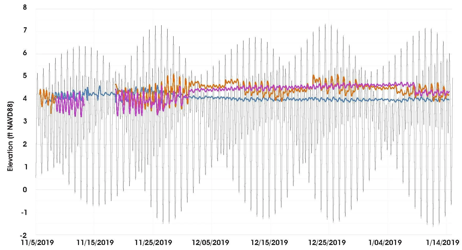
Tidal cycles and muted groundwater tidal responses.
The goal in groundwater model development and calibration is to reproduce the response in the model to what is physically observed in the groundwater system. Observations of groundwater levels collected at monitoring wells over time, and the response of groundwater levels with tidal fluctuations, were used to calibrate the model. If the observed groundwater response is reproduced in the model, there is greater confidence in model predictions of groundwater levels and the volume of groundwater captured by the drains.
Different cutoff wall designs, as well as various elevations of the playing field, were evaluated in the model simulations. Both design elements affect the volume of water that has to be collected, pumped, and treated from the perimeter drains. For example, a lower playing field elevation would require maintenance of lower groundwater levels, maintenance of lower groundwater levels would require correspondingly deeper drain elevations. Similarly, a partial cutoff wall would also result in higher groundwater inflows than a deeper cutoff wall set in low-permeability sediments. These factors would result in a larger volume of captured groundwater that would subsequently require collection, pumping, and treatment. As part of assessing the cutoff wall depth and playing field elevation, LWS evaluated the estimated increase in groundwater flow to the perimeter drains with extreme high tides. Daily tidal data from 2019 (Source: National Oceanic and Atmospheric Administration, NOAA) were used to create an approximate one-year tidal cycle. The increase in groundwater levels and, therefore, the increased flow to drains were evaluated at the period during the highest tides of the year.

Lagged groundwater response to tidal changes.
Each scenario of cutoff wall design, playing field elevation, and extreme high tide was also evaluated for projected future sea level rise. The predicted increase in groundwater levels and volume of water captured in drains flows on average and at extreme high tides offered important information for future planning. In this way the LWS model evaluated the effect of potential groundwater changes to the Year 2100 so the ballpark would have long-term protection from groundwater level changes.
A TOOL FOR ASSISTING THE OAKLAND A’S
The groundwater model of the area of the proposed new ballpark was a tool that assisted the A’s in making decisions on the design of the stadium and the local development. As the stadium design proceeded, the model results were used to assess methods of groundwater level control, such as the capture and reuse of return flows percolating below the playing field so water use is optimized. Unfortunately, for a variety of reasons, the A’s decided to move out of Oakland, Major League Baseball approved the move on November 16, 2023.
LWS has an experienced team of modelers that routinely use numerical models to evaluate complex surface water and groundwater hydrology issues, as well as address fate and transport of contaminants in groundwater. In addition, LWS often teams with other professionals to provide additional services related to modeling. For more information, please contact LWS at 303-350-4090 or contact our modeling team:
Maura Metheny, PhD, P.G. maura@lytlewater.com
Anna Elgqvist, EI anna@lytlewater.com
Marlena McConville marlena@lytlewater.com
Bruce Lytle, P.E. bruce@lytlewater.com